You're staring at a fiber route that looked clean in desktop review, then the make-ready package lands on your desk and the questions start piling up. Can this trench be dug without wrecking the schedule? Will the tower pad hold without overbuilding it? Is that wet low spot going to turn into a dewatering headache the first time the drill rig shows up? A geotechnical survey is the step that turns those guesses into design inputs before your crew commits to a foundation, a bore path, or a budget.
On telecom work, the survey isn't a generic soils exercise. It's a route-and-site risk check that helps answer what soil is present, how strong it is, where water sits, and whether hidden obstructions will get in the way. That matters because route-specific variability can change trench, foundation, and temporary support needs within short distances, so a single boring cluster rarely tells the whole story. The job is to convert unknown subsurface conditions into decisions about earthwork, pole embedment, tower pads, dewatering, and shoring, before the project team starts arguing over change orders.
If you're scoping a fiber build, the cleanest way to explain the value is simple. You're not buying a report, you're buying fewer surprises in the trench and a better shot at keeping the tower or route on schedule. If you also need adjacent infrastructure planning context, browse 2n telecommunications products from Amax Fire & Security Ltd. alongside your site package so the comms scope and the physical build don't drift apart. For tower-specific execution context, the cell tower construction overview is a useful companion to the subsurface work.
What a survey is not matters just as much. It isn't a Phase I ESA, it isn't a topo survey, and it isn't a construction inspection. It doesn't replace utility locating or engineering judgment either. It gives the designer better ground truth so the project manager can stop treating the subsurface like a blank spot on the drawing.
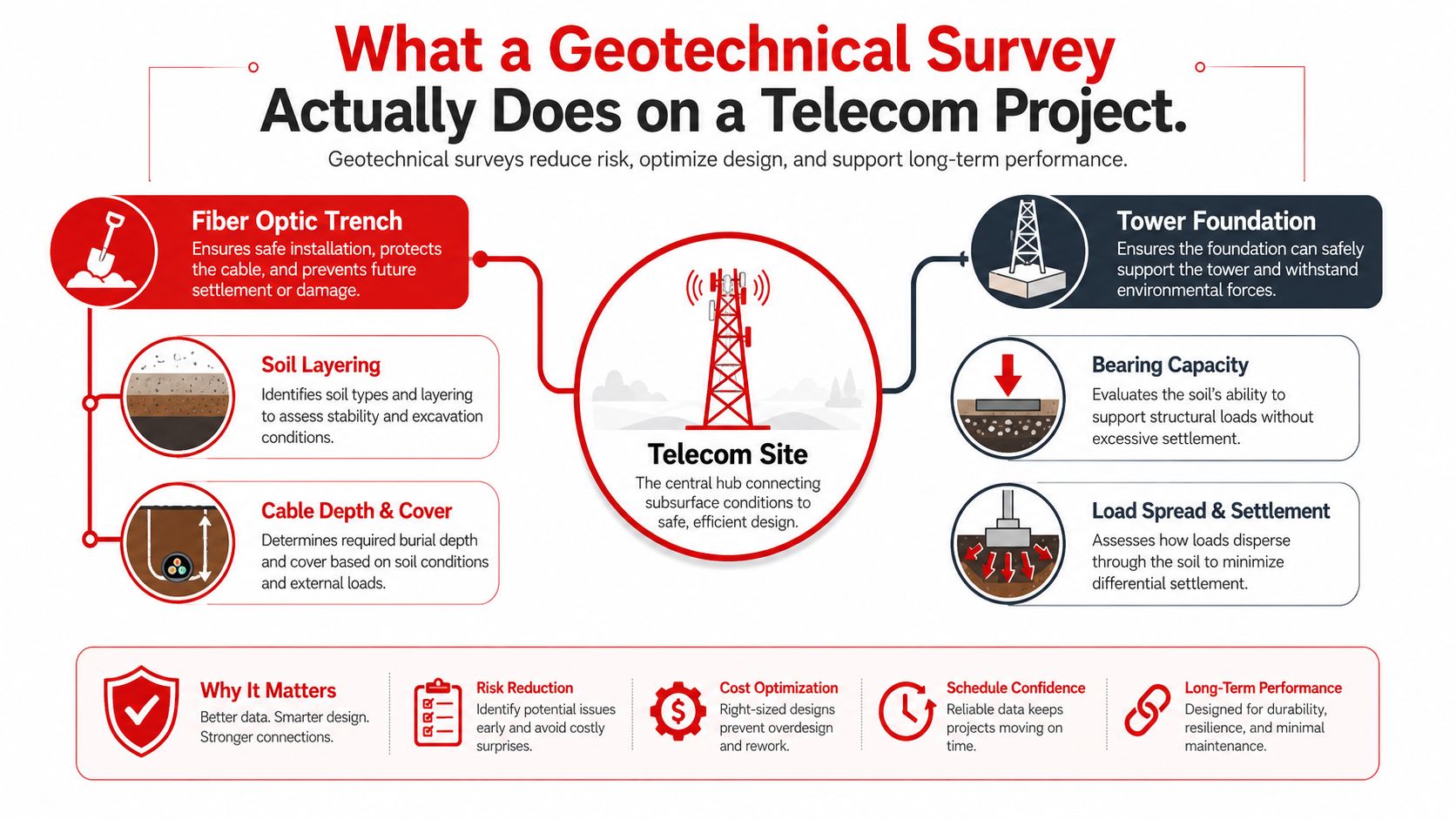
What a Geotechnical Survey Actually Does on a Telecom Project
A telecom project usually asks the ground one blunt question, “Can we build this the way we think we can?” On a fiber route, that might mean whether the trench can be opened without collapsing sidewalls or hitting shallow rock. On a tower upgrade, it means whether the soil can carry the pad, poles, or anchors without unexpected settlement.
The four answers that matter
A good geotechnical survey gives you four things that affect money and schedule immediately. First, it identifies the soil and fill conditions along the route or at the site. Second, it tells you how strong or compressible those soils are. Third, it shows where groundwater is likely to interfere with excavation or drilling. Fourth, it helps flag buried surprises, such as rock, voids, old foundations, or utility conflicts, that a clean surface view will never show.
Practical rule: if the design changes when the ground changes, the survey has to match the ground, not just the parcel boundary.
That's why the scope should follow the build type. A short tower access road, a pad expansion, and a long linear fiber corridor all carry different subsurface risks. A route can cross wet fills, firm native soils, and shallow refusal in a matter of hundreds of feet, and the design response isn't the same in each zone.
The survey also drives constructability decisions. For a fiber job, that means trench depth, dewatering, bedding, and restoration. For a tower, it means embedment depth, foundation type, and whether the pad needs to be widened or thickened. If HDD is part of the plan, groundwater and weak soils become just as important as bearing capacity because the drill path can be affected long before the structure is built.
What it does not do is solve every uncertainty. A report can't see through every buried obstruction, and it doesn't guarantee conditions won't change after the field work. But it does give the project team a defensible starting point, which is exactly what a telecom PM needs when the contractor starts talking about extras.
How Geotechnical Surveying Became Standard Practice
Telecom owners didn't invent subsurface risk, they inherited it from a much older surveying culture. One early milestone was Lambton's Trigonometrical Survey of India in 1802, launched under William Lambton. That project extended across the subcontinent and produced the Great Arc of the Meridian, which is widely recognized as a turning point in large-scale ground measurement because it improved mapping accuracy and later helped enable the scientific determination of Mount Everest's height. The lesson still applies on telecom jobs, route alignment gets better when the ground is measured systematically rather than assumed.
A later institutional shift came with the U.S. Geological Survey, formally established on March 3, 1879, when President Rutherford B. Hayes signed it into law. That mattered because government-led terrain and subsurface investigation helped standardize the kind of geological and geotechnical information civil projects depend on now. Modern highway and utility work benefits from that lineage every time a design team asks for soil logs instead of opinions.
FHWA's geotechnical research program traces back to the 1970s, when field personnel and State Highway Agency engineers needed help with soil behavior and foundation problems. That's the bridge to today's telecom work. The core questions haven't changed much, even if the infrastructure has. Engineers still need to know what's under the route, where refusal or instability will occur, and how much confidence the design can carry into construction.
The reason this history matters is simple. A geotechnical report isn't a guess dressed up in technical language. It inherits methods for measurement, classification, and interpretation that were built to reduce uncertainty in the field. On a fiber build or tower site, that lineage shows up as better refusal calls, better foundation recommendations, and fewer disputes when conditions on the ground don't match the assumptions in the estimate.
Field and Lab Methods Used in Telecom Surveys
A telecom survey is only as good as the field program behind it. A couple of borings can be enough on a small, uniform pad, but that approach breaks down on a long corridor, mixed fill, shallow groundwater, or fractured rock. The scope has to sample the right locations and capture enough variation to matter when the crew starts trenching, drilling, or setting foundations.
What the field crew is doing
The first tool is usually a boring, because the team needs a direct look at the subsurface. That boring is often paired with standard penetration testing, which gives blow counts that help estimate relative density or consistency and support bearing and liquefaction screening. Federal and agency guidance commonly calls for SPT blow counts and USCS classification at about 0.75 m intervals in major-structure investigations, while other guidance calls for continuous or closely spaced SPT sampling in the upper 4.5 m and then at significant changes in strata. USACE geotechnical investigation guidance lays out that logic clearly.
Rock changes the method. If the site is in rock or shale, continuous coring matters more than a quick refusal note. Double or triple tube barrels are recommended, and for structural foundation work the core should extend at least 3 m into rock to confirm bedrock rather than a boulder. That distinction matters on telecom pads or tower anchors, because a shallow boulder can make a shallow exploration report rock where there is only a large obstruction.
Groundwater observation belongs in the same scope. A boring that does not document water conditions can leave the HDD team guessing, and guessing costs time. Test pits can also help where shallow utility corridors, trench lines, or access roads need visual confirmation of fill depth and near-surface transitions. On projects with heavy coordination and field sequencing, the construction project context helps frame why this kind of early field verification saves later rework.
What the lab tells you that the field can't
The lab turns samples into engineering parameters. USCS classification tells you what the soil is. Compaction testing and related index work help show whether the material can be reused, stabilized, or needs replacement. That is the part of the report that later informs trench backfill, access road restoration, and pad preparation.
Field note: coarse sampling intervals miss weak seams. The bad seam is the one that shows up during excavation, not the one that was easy to describe in the report.
For a telecom PM, the practical question stays the same, does this support the design we are trying to build? A boring cluster can answer that on a short site, but along a route it often cannot answer enough. The survey scope needs enough coverage to catch the transitions that drive construction pain, not just the spots that are easy to drill.
For a broader construction-oriented example of how field data gets turned into work planning, the AdVoltage Electrical data cabling example is a useful parallel, even though the subsurface work is obviously a different discipline. The same principle applies, better site data up front means fewer surprises in the field.
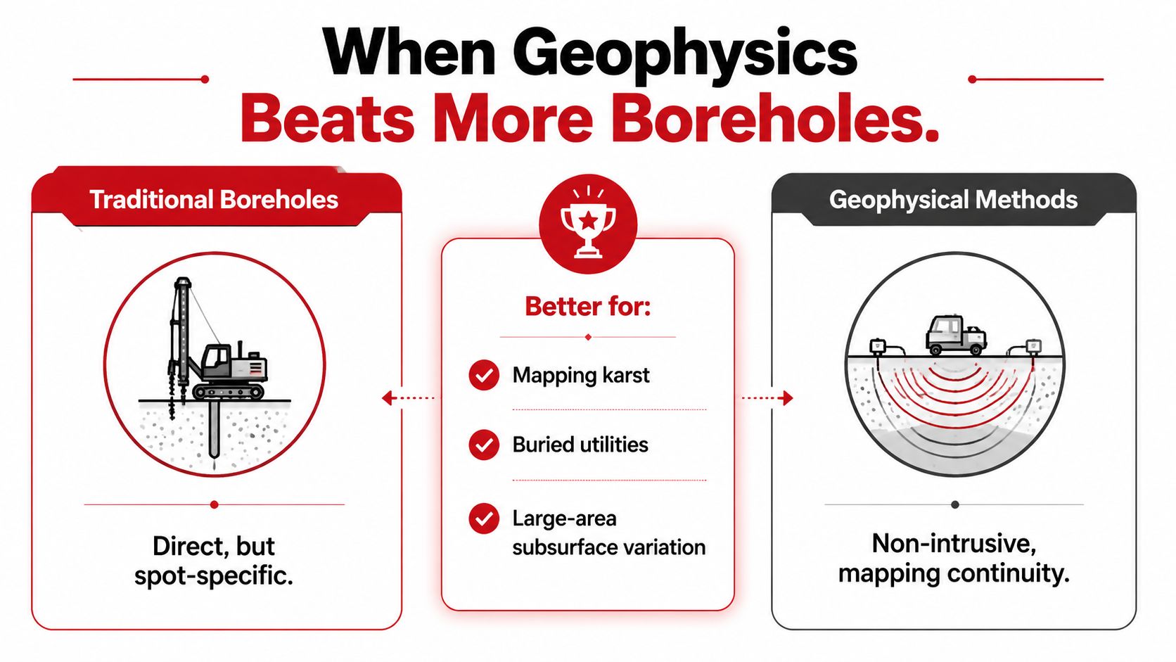
When Geophysics Beats More Boreholes
A lot of telecom corridors don't fail because the engineer ignored soil. They fail because the engineer assumed the boring pattern could see everything. On long, uneven routes, that's not realistic. You need direct sampling, but you also need a way to see continuity between the holes.
Where borings stop helping
Boreholes are direct, but they're spot-specific. That makes them excellent for confirming soil type at a tower pad or a crossing, and weaker for mapping what happens between widely spaced access points. On a fiber corridor, a few good borings can still leave you blind to shallow bedrock, sinkholes, abandoned mine features, or a buried utility that sits just outside the drill pattern.
What geophysics adds
FHWA and TRB guidance says geophysical methods are used to characterize bedrock depth, weak zones, groundwater, sinkholes, abandoned mines, and buried utilities, and that seismic, GPR, and vibration monitoring are among the commonly used methods. TRB's geophysical methods circular reflects the practical reason these tools get pulled into corridor work. They cover more ground, and they highlight anomalies that deserve a targeted boring instead of a blind one.
That doesn't mean geophysics replaces borings. It means the two methods should work together. Start with desktop review and geophysics when the route is long, the obstruction risk is murky, or the cost of missing a problem is high. Then place targeted borings where the geophysics flags a change, a void, a weak zone, or a suspicious transition.
The decision rule is straightforward. If you need a yes or no on a specific foundation point, bore it. If you need to understand what's happening continuously along a corridor, screen it first, then drill where the map gets messy.
How to Read a Geotechnical Report
A useful geotechnical report reads like a set of instructions, not a ceremony. The pages that matter first are the ones that tell you what the designer can build without fighting the site. If the project is in trouble, that's where you look before you start blaming the contractor.
Start with the boring logs and groundwater notes
The site description and exploration plan tell you where the work was done and how much confidence the coverage deserves. The soil profile logs show the sequence of strata, the depth to refusal, and whether there are soft zones, fill, or rock transitions that could alter trenching or foundation design. Groundwater observations matter just as much, because a dry boring and a wet boring can lead to very different excavation and dewatering plans.
The findings section is where you separate facts from recommendations. A finding says what was encountered. A recommendation translates that into a design action, such as deeper embedment, a wider pad, a different backfill, or a change in HDD approach. If the report says conditions were “based on what was encountered,” that language matters, because it usually limits the recommendation to the sampled locations, not the whole parcel.
“Based on conditions encountered” is the phrase that keeps a smart contractor honest and a careless owner from overreading the report.
Read it like a telecom decision document
For a tower, the key pages usually answer bearing capacity, settlement, and construction recommendations. For a pole line or access road, the answer may live in the pavement section, slope stability notes, or trench support guidance. For HDD, the red flags are groundwater, collapsible fill, shallow rock, or any statement that suggests the boring pattern didn't fully resolve the crossing.
If the report includes R-value or pavement recommendations, that matters for access roads and staging areas, not just the permanent build. If it discusses dewatering, shoring, or construction limitations, those comments often drive the cost of the job more than the neat foundation sketch on the cover page.
The fastest way to use the report is to read the summary, then jump straight to the recommendations tied to your problem site. That's where you find the basis for pushback when a bidder tries to load the estimate with extras that the subsurface data doesn't support.
Timeline, Cost Drivers, and What Actually Moves the Number
The cost of a geotechnical survey is usually driven less by the word “survey” and more by access, depth, and how many times the crew has to come back. A single tower site can move quickly if the location is open, the utility locate is clean, and the scope is tight. A long fiber corridor is different, because every special crossing, wet area, and access constraint adds coordination.
What drives the schedule
Access is the first gate. If the drill rig can't get in easily, the crew waits or the scope changes. Groundwater and rock depth also affect pace, because they can change the drilling method and the number of samples needed before the engineer is comfortable signing off. When groundwater monitoring is part of the scope, the project can require more than one site visit, and that adds time even when the drilling itself is straightforward.
Permitting and utility coordination can be quiet schedule killers. A crew can be ready to mobilize and still sit on standby while locates get cleared or traffic control gets arranged. If the project has a review cycle, remobilization for an additional boring after comments come back can move the budget more than the original hole did.
For telecom owners, the best cost control is boring scope discipline. Align the exploration plan with the make-ready schedule, confirm access before mobilization, and get the field layout approved before the truck rolls. If the design team keeps revising the site plan after the crew has started, the survey cost starts leaking into repeat travel, extra drilling, and extra report revisions.
If you're pairing the geotechnical plan with a horizontal drill package, the HDD project overview is a useful reminder of how much subsurface uncertainty gets pushed into the boring and crossing plan.
Integrating the Survey With Permitting, Make-Ready, and Construction
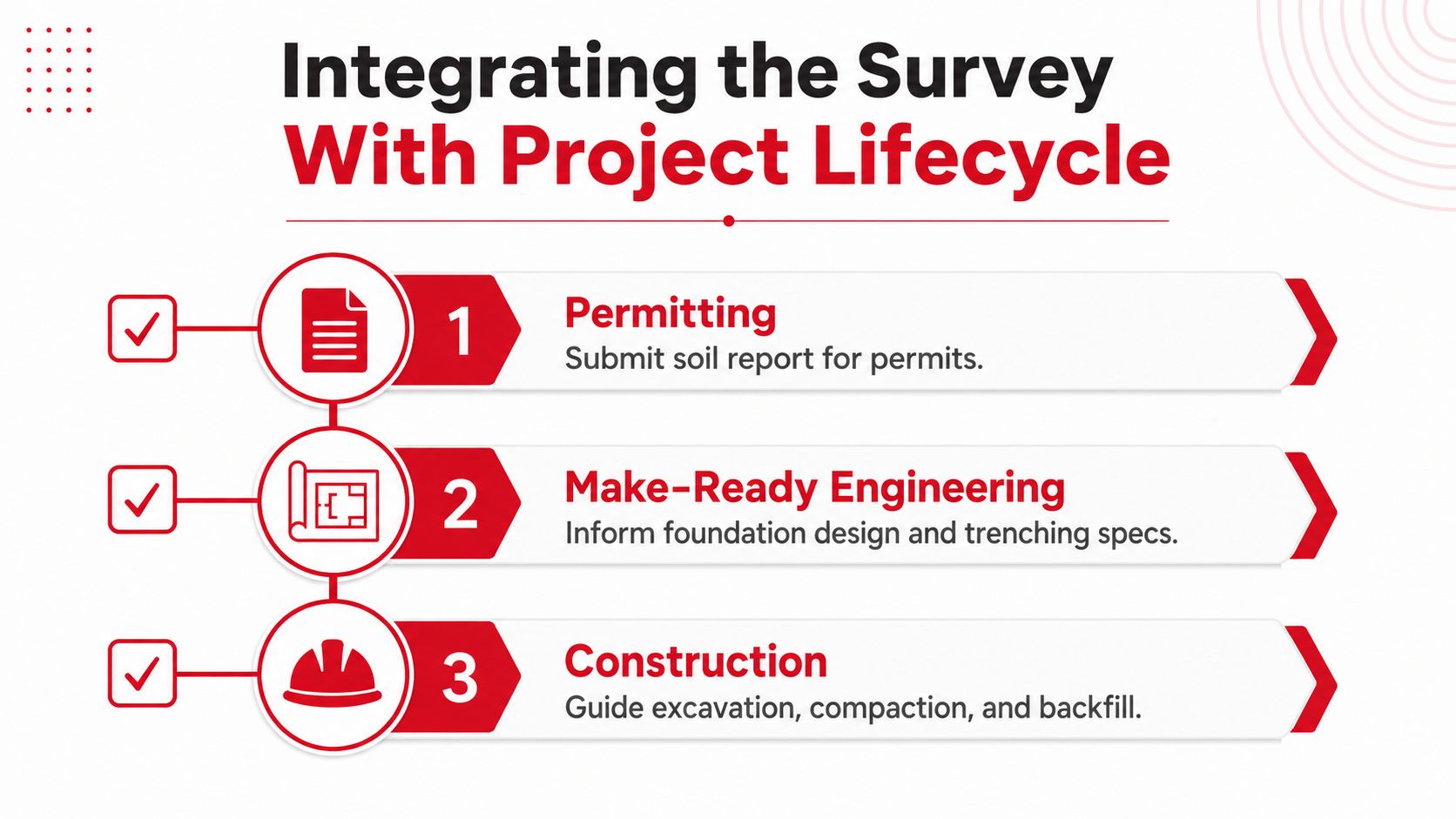
A report earns its keep when it changes another document. If the geotechnical findings never make it into the permit set, foundation package, HDD plan, or construction sequence, the project still carries the same hidden risk. The handoff point is where a lot of telecom teams either save the schedule or lose it.
Where the findings land
Permitting packages often need the report to support the chosen foundation or trenching approach. Make-ready engineering uses the same data to defend pole attachment or foundation decisions when the pole line gets reworked. On tower sites, the geotechnical recommendations flow directly into the foundation design package, and that can change the excavation size, reinforcement, or construction sequence before anyone pours concrete.
The construction team also needs the report to make real field calls. Expansive soils can change the backfill or slab detail. A high water table can alter dewatering and HDD sequencing. Shallow rock can force a redesign of the excavation plan. Contamination or unsuitable fill can trigger material handling changes that the original schedule never allowed for.
For broader site visibility during execution, a live construction camera for PMs can help verify whether the field crew is following the sequence the report assumed, especially when multiple subcontractors are moving through a tight site.
When to recheck the ground
The report is only as current as the ground conditions it captured. If the site has major weather exposure, groundwater changes, slope movement, or signs of new settlement, it deserves another look before construction locks in. That matters on critical infrastructure because the ground doesn't stop changing just because the report is on file.
The cleanest way to protect the schedule is to treat the survey as a living input. Revalidate when the site changes, when a crossing gets redesigned, or when the field conditions no longer match the assumptions in the report. That's how the survey stays useful instead of becoming a PDF nobody trusts.
Client Action Items and a Risk Mitigation Checklist
Before the survey, get the desktop study, utility locate plan, and access constraints aligned with the design team. During fieldwork, keep one person responsible for change control so extra borings don't get added casually in the field. After the report lands, review the findings against the trench plan, the tower foundation package, and any HDD crossing before the contractor prices in avoidable risk.
Risk check: bearing failure, settlement, trench collapse, HDD frac-out, pavement failure, and tower foundation rejection all map back to specific report outputs, especially soil profile logs, groundwater notes, and design recommendations.
If you need a one-page summary for a PM or client, use this sequence:
- Before mobilization: confirm access, scope, and the exact structures or crossings that need coverage.
- During the survey: document any field changes immediately and make sure the boring layout still matches the build.
- After delivery: compare the recommendations to the actual design, then flag any site that needs revalidation before construction starts.
A geotechnical survey is worth the cost when it protects a route, a tower, or a schedule from avoidable ground risk. Southern Tier Resources helps telecom teams turn field data into buildable infrastructure, from fiber and make-ready work to tower construction and documentation. If your next project needs a partner that understands how subsurface conditions shape the work above them, visit Southern Tier Resources and start the conversation early.